History of Bandarban

In the early days of 15th century, Arakanese kingdom expended its territories to the Chittagong area of Bengal. After the victory of Arakan on Burma’s Pegu kingdom in 1599 AD, the Arakanese king Mong Raja Gree appointed a Prince of Pegu as the governor of newly established Bohmong Htaung (Circle) by giving the title of “Bohmong” Raja. That area was mostly populated by the Arakanese descendants and ruled by the Burmese (Myanmar) noble descendants who started to call themselves in Arakanese language as Marma. Marma is an archaic Arakanese pronunciation for Myanmar. As the population of the Bohmong Htaung were of Arakanese descandants, these Myanmar-desendants Bohmong chiefs (Rajas) of the ruling class took the titles in Arakanese and speak a dialect of the Arakanese language.

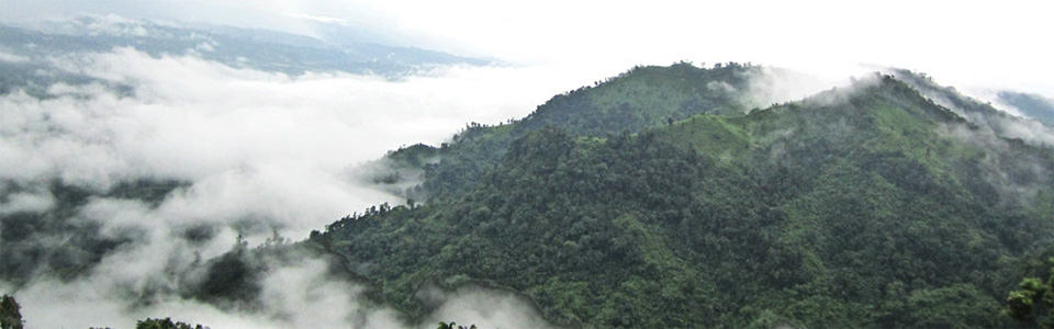
Bandarban Hill District was once called Bohmong Htaung since the Arakanese rule. Once Bohmong Htaung was ruled by Bohmong Rajas who were the subordinates to the Arakanese kings. Ancestors of the present Bohmong dynasty were the successor of the Pegu King of Burma under the Arakan’s rule in Chittagong. In 1614, King Mong Kha Maung, the king of Arakan appointed Maung Saw Pru as Governor of Chittagong who in 1620 repulsed the Portuguese invasion with great valour. As a consequence, Arakanese king, Mong Kha Maung adorned Maung Saw Pru with a title of Bohmong meaning Great General. After the death of Maung Saw Pru two successors retained Bohmong title. During the time of Bohmong Hari Gneo in 1710, Arakanese King Canda Wizaya recaptured Chittagong from the Mughals. Bohmong Hari Gneo helped King Canda Wizaya in recapturing Chittagong and as a mark of gratitude the later conferred on Bohmong Hari Gneo the grand title of Bohmong Gree which means great Commander in Chief.

During the British Raj, it was declared as the Bohmong circle with limited autonomy. The Mizokaba or the Mizo uprise in the mid 19th century was major catalyst for re-settlemet of the tribes in the area. During World War II the area saw the presence of a formidable British military presence that came to stand against a Japanese invasion. The tribes of these hills held the reputation of unyielding rebellion throughout history. When India]], Pakistan and Mynamar went independent from the Raj, the leaders of the tribes people decided unsuccessfully to become a part of Mynamar, then known as Burma. During the Bangladesh Liberation War of 1971 to gain independence from Pakistan, the leaders again sought unsuccessfully to remain a part of Pakistan.

In the late 1970s, a policy of forced settlement of Bengalis into hills was pursued, which later gave rise to much violence against the hill people and the insurgency led by Shanti Bahini, the military wing of Parbatya Chattagram Jana Sanghati Samiti. There have been an attempt to create divide among tribal cultural lines between the Chakmas, who led Shantibanhini, and the Mrus, by creating an anti-Shantibanhini militia out of them. Now, after the peace treaty, Bandarban stands as a locally governed ethnic region together with the two other hill districts. Representation of numerous tribes of the district in the Hill Council now stands as a thorn of dispute here.

VN:F [1.9.8_1114]
Rating: 4.4/5 (8 votes cast)
VN:F [1.9.8_1114]
Rating: +4 (from 4 votes)

Popular Search Terms

boga lake bandarban bangladesh (98), www hdcbandarban org (23), BAndarban history (17), I want to about bandarban tourist area chattagram (1)

Nilgiri

Nilgiri or Nil Giri is one of the tallest peaks and beautiful tourist spot in Bangladesh. It is about 3500 feet high and situated at Thanci Thana. It is about 46 km south of Bandarban on the Bandarban-Chimbuk-Thanchi road. Beside this spot you can see Mro villages. Their colorful culture and living style are surely an unexplored experience for the visitors. In rainy season here creates a spectacular scenery, the whole spot is covered with the blanket of clouds. You can enjoy a cloudy experience. Winter is waiting for you with it’s foggy gesture on the height. It is a nice place for campfire in that season. Most attractive time is the dawn. It is better if you chose to stay during 7-18 dates of a lunar month to enjoy the moonlit night. You can also enjoy the serpentine course of Sangu River. This is the most spectacular tourist spot in Bandarban and managed by Army brigade of Bandarban.

VN:F [1.9.8_1114]
Rating: 4.3/5 (10 votes cast)
VN:F [1.9.8_1114]
Rating: +9 (from 11 votes)

Popular Search Terms

nilgiri bandarban resort Booking (184), tourist spot in bandarban bangladesh (96), nilgiri cottage bandarban (68), www bandarban nilgiri com (53), thanci (26), nilgiri in bandarban bangladesh (19), nilgiri height from sea level (15), nilgiri hight (14), hight of nilgiri (13), https://www bandarbantours com/search/height-of-nilgiri-bandarban/ (12), height of nilgiri from sea level (12), nilgiri height bd (4), nil gire bangladesh (1), nil giri koto foot occota (1), hight of nilgri hill (1), nilgiri bangladesh height (1), hight of nilgri (1), nilgiri hill bandarban height (1), What is the height of Nilgiri bandarban (1)

Bandarban

In Bandarban there are many incredible place and tourist spot. There are many hotels, motels and nice hill resorts in Bandarban. Some resorts are situated on a hilltop and has a spectacular view. The more adventurous travelers can stay these resorts.tribal house

VN:F [1.9.8_1114]
Rating: 3.0/5 (3 votes cast)
VN:F [1.9.8_1114]
Rating: +1 (from 1 vote)

Sangu River, Bandarban

Sangu River is the complete part of the natural beauty of Bandarban. It follows a northerly circuitous course in the hill tracts up to Bandarban. It enters the district from the east and flows west across the district and finally falls into the bay of Bengal at the end of a course of 270 km. This river is flowing through the hills thousands of years. It is an important route to communicate with Ruma and Thanchi Upozilla. It has huge financial interests for the population of Bandarban. This river is widely used for transportation, agricultural and other necessary products for the people of remote community. In the winter season the current of the river almost becomes stagnant but in the rainy season the current becomes aggressive. Visitor must be attract with the beautification scattered on the both sides of it. You can find here hills, forests, falls with a river together. All the way you will be thrilled only and it is simply amazing.

VN:F [1.9.8_1114]
Rating: 5.0/5 (1 vote cast)
VN:F [1.9.8_1114]
Rating: 0 (from 0 votes)

Boga Lake, Bandarban

Boga Lake is the most beautiful natural lake in Bangladesh. It is also known as Bagakain Lake or Baga Lake. Boga lake is 18 kilometer away from Ruma Sadar Upozilla in Bandarban. The area of this lake is about 15 acres. It is about 3000 feet above sea level. The color of water of this lake is blue and very nice. There are many mythological stories behind the creation of this lake. There are many tourists make their way to Boga lake every year, specially in the winter season. Small tribe community like Bawm, Khumi have localities besides the Boga lake. In the rainy season, it is quite difficult to stroll beside the boga lake. The road from Ruma to Boga lake is still under construction. There waiting lots of pleasure and delight for you at Boga lake. You will definitely be amazed looking at the big rocks lying in and out of the Boga lake. You can have a camp fire beside the lake, that will be unbelievable and mind-blowing memory in your life.

VN:F [1.9.8_1114]
Rating: 4.8/5 (6 votes cast)
VN:F [1.9.8_1114]
Rating: 0 (from 4 votes)

Popular Search Terms

boga lake bandarban (299), bandarban boga lake (148), bogalake (66), bogalake bandarban (35), boga lake cottage bandarban bangladesh (15), BogaLake|Bandarban|BandarbanBogalake|bogalake|Bandarbanplaces|PlacesofBandarban| (14)

Shoilo Propat

The waterfall named Shoilo Propat or Shoylo Propat at Milanchari, 4 km from the town on the road to Thanchi, is also excellent site maintained by Bangladesh Parjatan, the national tourism promotion corporation. The Parjatan Motel is not a small thing at all. It has a huge three-storey building on a high place. The room rent here a little high compared to other places The site maintained by the District Administration is Meghla, 4 km from the town on the road to Keranihat, which features a mini-safari-park, a zoo, and a hanging bridge. The District Administration has also developed the Nilachal tourist site near Meghla, in Tigerpara.
Shoilo Propat is one of the most famous and visited natural fall in Bangladesh. During the rainy season the flow of this fall becomes vigorous. The water of this fall is so cool and transparent Near the Shoilo Propat there has grown up two or three village for the availability of water. It is a good source for drinking water and household use for the local community.
There is a small market near the Shoilo Propat for trade local peoples handicrafts, handloom products and food. Visitor can closely see the struggling lifestyle of this region community.

VN:F [1.9.8_1114]
Rating: 5.0/5 (2 votes cast)
VN:F [1.9.8_1114]
Rating: -2 (from 2 votes)

Popular Search Terms

ShoiloPropat|Bandarban|BandarbanShoiloPropat|BandarbanShoyloPropat|Bandarbanplaces|PlacesofBandarban|BandarbanShoilopropat|Soilopropat| (22)

People of Bandarban

There are more than fifteen ethnic minorities living in the district besides the Bengalis, including: the Marma, the Arakanese descendants and Arakanese (Rakhine), who are also know as Magh, Mru (also known as Mro or Murong), Bawm, Khyang, Tripuri (also known as Tipra or Tipperah), Mizo (also known as Lushei), Khumi, Chak, Kuki, Chakma and Tenchungya, who are closely related, Reang (also known as Riyang), Uchoi (also known as Usui) and Pankho.

The Mru, also known as Murong, who are famous for their music and dance. The Mru in major numbers have converted to Khrama (or Crama), the youngest religion in Bangladesh that prohibits much of their old ways. They are assumed to be the original inhabitants of Bandarban. The Bawm are another major tribe here. Now converted almost totally to Christianity they have taken full advantage of the church to become the most educated people in the district. The Marma are Arakanese descendants of Myanmar by origin and Buddhists by religion, and are the second largest tribe in the hill districts of Bangladesh. The Khumi live in the remotest parts of the district, and the group is thought to include yet unexplored/ unclassified tribes.

These ethnic groups are again divided in hundreds of clans and sects, principally dominated by four religious threads – Buddhism, Christianity, Hinduism and a number of pagan faiths. All these clans and groups are clustered into two major ethnic families, namely the hill people and the valley people. Since the Kaptai dam flooded the valley creating to Kaptai lake, the valley people have started to live on hill tops along the hill people.

Bengali settlers, coming in with the forced settlements in 1979, and Rohingya settlers, coming in across the Myanmar border since the junta came to power in Yangon in 1992, now has become two major ethnic groups outside minorities. But, there are a number of Bengali families who claim to have settled earlier than some of the tribes.in there live many Barua also.

VN:F [1.9.8_1114]
Rating: 5.0/5 (2 votes cast)
VN:F [1.9.8_1114]
Rating: 0 (from 2 votes)

Popular Search Terms

Celebrity born in Bandorban (1), kuki propat (1)